DJI Ground Station Pro
Tax: Included
Enhance your drone operations with the DJI Ground Station Pro (DJI GS Pro), an iPad app. Conduct automated flight missions, manage flight data on the cloud, and collaborate across projects to efficiently run your drone program.

DJI GS PRO
MISSION-CRITICAL FLIGHT SIMPLIFIED
Enhance your drone operations with the DJI Ground Station Pro (DJI GS Pro), an iPad app. Conduct automated flight missions, manage flight data on the cloud, and collaborate across projects to efficiently run your drone program.


FLIGHT DATA MANAGEMENT
Back up flight data securely on the cloud, giving missions higher reliability and accuracy. Reference historical information on flight missions, aircrafts, members, and flight logs so that workflows can be optimized.
Flight mission data is visible to all members of a project team, making data sharing easier. Members can view edits made by other team members, or duplicate flight parameter settings for new missions.
FLEET AND PILOT MANAGEMENT
Manage pilots and drones through the creation of teams, making missions more coordinated. Designate roles with different permissions to improve communication. Track the status of aircrafts to make proactive purchasing and maintenance decisions.


PROJECT MANAGEMENT
Improve the efficiency of your drone operations by tracking individual projects and streamlining the project management process. Access to project status can be granted on a per project basis so that critical data is only available to the relevant members.


3D MAP AREA
GS Pro automatically generates efficient flight paths after the user has set their required flight zone and camera parameters. The aircraft will then follow this route throughout its mission. The image data captured during these flights can be input into 3D reconstruction software to generate 3D maps, while the mission itself can be saved for re-use.

Custom Flight Zones
Draw a custom polygonal flight zone on-screen or fly around the zone to mark zone boundaries using the aircraft’s GPS coordinates.

Adjust Parameters
Adjust parameters including photo overlap ratio, altitude, shooting angle — parallel or vertical to the main flight path — course angle, and margin. Capture images at equal time intervals, equal distance intervals, or to hover at a waypoint during capture.

Inside Mode and Scan Mode
Two Flight Course Modes are available: Inside Mode, in which the aircraft follows an automatically generated routed within the chosen area and Scan Mode which provides the fastest route to cover a designated area.

Flight Plan Overlap Ratio
To achieve better 3D reconstruction, the default photo overlap is optimized for a range of supported cameras. It can also be independently adjusted.


3D Map POI
3D Map POI excels in gathering the critical data of a structure, and is especially useful for measuring tall skyscrapers and towers. Just tap the structure on the screen and enter its basic parameters, then GS Pro will direct the drone and camera to gather the precise data you need. Through a number of customizable features like Circle and Vertical mode, 3D Map POI provides complete accuracy for effective structural management.

Circle Mode
After setting the drone's altitude range and flight radius, photo overlap ratio, and the structure’s radius, GS Pro will prompt the aircraft to fly in a circular path around the structure at different altitudes from top to bottom, using its photos to generate a composite 3D image according to the user’s settings.

Vertical Mode
After setting the drone's altitude range and flight radius, photo overlap ratio, and the structure’s radius, GS Pro will prompt the aircraft to follow a vertical flight and shot path along the structure, automatically relocating to the next path until it can generate a composite 3D image according to the user’s settings.
Vertical mode operates in three shooting modes: In Hover-and-Capture mode, the aircraft will calculate an increased number of waypoints that create vertical paths, and hover at each one, capturing images at maximum shot stability. In Capture at Equal Distance Interval / Time Interval mode, the aircraft will continuously fly along the main path, shooting at equal distance or time intervals while moving along vertical paths for faster operation.


Safety Instructions
In Circle and Vertical mode, the aircraft will fly in a straight path between waypoints, so the actual distance between the aircraft and the structure may sometimes be shorter than the preset flight radius. During Capture at Equal Distance/Time Interval mode, the aircraft will fly along a parabola and the distance to the shooting target may be longer than the preset radius, so please make sure the surrounding area is open and large enough to avoid collision risks. To ensure flight safety, operators on the ground should move along with the aircraft to maintain line of sight as the aircraft flies around the structure.
In Vertical mode, the aircraft will fly up and down many times at a relatively low speed (1~4 m/s, although speed varies from different aircraft modes), which will lead to a longer shooting time and faster consumption of the battery level.
When resuming operations in Circle or Vertical mode, the aircraft will first ascend directly to a height equal to the previous waypoint, then fly towards it. To avoid collision risks, be sure there are no ceilings or buildings above the aircraft.


IMPORT KML/SHP FILES
To import KML/SHP files via a PC or Mac, open GS Pro, choose “File”, click “Start import”, and a prompt containing an IP address will show up. Enter the address into any browser installed on the PC or Mac, and choose “Upload Files” on the webpage. Users will find the file in GS Pro under the “File” folder when it’s been successfully uploaded. Users can also do this with an iPad by downloading KML/SHP files via Safari or email and following the instructions to import the files into GS Pro. If the files users import are in KMZ or ZIP format, GS Pro will decompress them automatically into GS Pro’s “File” folder.

IMPORTING GEOMETRIES OF A TARGET BUILDING
Swipe the KML/SHP file you want to the left, and tap “Import”. GS Pro will automatically process the file and generate geometries in the “Map” folder.

CREATING A FLIGHT MISSION
Swipe a task in “Map” folder to the left and tap “Create Mission”. Choose a mission type and a flight mission will be created automatically.
Notes
GS Pro supports KML, SHP, KMZ, and ZIP formats and automatically decompresses KMZ and ZIP files when importing from an iPad.
GS Pro can generate polygons, line strings, and points. Points cannot be used to create a flight mission, yet can be used as a reference for GCP (Ground Control Point) setup.
Currently, WGS-84 is the only coordinate system supported by GS Pro.
PHOTOMAP
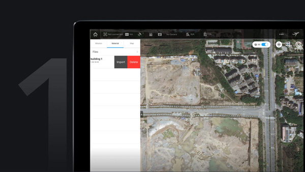
Import Photos
After taking the required amount of photos in PhotoMap mode, users will be prompted to import them into GS Pro. To import photos, users can either download them from the aircraft via DJI GS Pro or import the photos directly to the iPad first and then open in GS Pro. Due to slow download speeds, we suggest users use an iPad SD card reader if importing a large number of photos.

Create a Map
Tap a material in the Material list, enter the material editor and then choose the photos you will use to make the composite. Tap the Compose icon on the top right corner of the screen, initiating the process. When complete, a red dot will appear on the Map tab. Tap the Map tab, where you can see all your composed maps.

Manage the Map
Tap the Map list and choose a composed map for viewing. Swipe left to calibrate, pin, or delete the map.

Calibrate the Map
Due to positioning deviation during the flight mission and limited photo image quality, the composed 2D map will inevitably have a degree of bias. Calibration helps to compensate the bias by letting users mark three or more calibration points on the map, obtain their actual GPS locations and then calibrate the map in GS Pro. Generate a control point by tapping onscreen. After marking three or more control points, tap the Calibrate icon on the top right of the screen. Once complete, a calibrated map will appear.
TAP AND GO WAYPOINT FLIGHT

Multiple Waypoints
Set a waypoint flight path, define waypoint actions, then start flying with a tap. Up to 99 waypoints are available, depending on the needs of each flight.

Adjustable Parameters
The altitude, speed, gimbal pitch and aircraft rotation (clockwise or counterclockwise) at each waypoint can be pre-defined.

Various Waypoint Actions
Each waypoint can have up to 15 consecutive actions, including aircraft rotation, gimbal pitch, start/stop recording, photo capture, and hover.

Set End-Mission Actions
After the aircraft finishes its flight mission, it can be set to Return to Home, Hover, or Land.
VIRTUAL FENCE
Virtual fence defines a specific area of flight and is useful in scenarios where some areas of a site are no-fly zones or if flight should only happen within one area, such as during manual pesticide spraying or flight. It is also useful in pilot training situations. As the aircraft approaches the virtual fence, it will brake and hover to ensure it stays within the flight area.

Set Virtual Fence Range
The size and shape of the Virtual Fence is completely customizable. It can be created pre-flight, or fly around the zone to mark boundaries using the aircraft’s GPS coordinates.

Speed and Altitude
Set the maximum speed and altitude for the aircraft when flying inside Virtual Fences.


INDUSTRIAL APPLICATIONS
DJI GS Pro is a powerful, convenient and easy to use tool. With just a few taps on an iPad, complex flight routes can be created, giving critical missions added accuracy and reliability. DJI GS Pro is an indispensable tool that is capable of dramatically increasing efficiency in a wide range of industries.


COMPATIBLE PRODUCTS
DJI GS Pro is compatible with the following DJI aerial platforms and flight controllers: Mavic 2 Enterprise, Mavic 2 Pro, Mavic 2 Zoom, Mavic Pro, Phantom 3 Standard / Advanced / Professional / 4K, Phantom 4, Phantom 4 Pro, Phantom 4 Pro V2 / Advanced, Phantom 4 RTK, Matrice 200 V2, Matrice 210 V2, Matrice 210 RTK V2, Matrice 210, Matrice 210 RTK, Matrice 100, Matrice 600 / Pro, Matrice 200, Inspire 1 / Inspire 2, A3, N3.
COMPATIBLE CAMERAS
Mavic 2 Enterprise, Mavic 2 Pro, Mavic 2 Zoom, Mavic Pro, Phantom 3 Standard / 4K / Advanced / Professional, Phantom 4 / Pro, and Zenmuse X3, X5, X5R, X4S, X5S, Z3, Z30, XT, XT2 and Mavic 2 Enterprise Dual.


Two Fast Replacements
DJI Care Refresh offers up to two replacement units* within one year, giving you total peace of mind.

Comprehensive Coverage
Covers accidents, such as user error and collisions. We’ll replace your aircraft even if it’s water damaged

VIP After-sales Service
Get prioritized support and skilled advice from DJI’s product experts.All shipping fees are covered by DJI.